Final project
For your final project you will develop a research project that uses mapping to support or research some aspect of Newark Forward: A blueprint for Equitable Growth and Opportunity in Newark. Students are encouraged to focus in particular on the plan’s consideration of Housing, Environmental Sustainability, and Inclusive Development. You may also propose a topic related to another current planning effort or current event in the City of Newark that is of interest to you, pending instructor approval.
Schedule
November 4, topic proposal due
November 10 @ midnight, methodology due
November 18, revised methodology, design precedents + preliminary maps due
November 25 No class (Friday classes meet on this day) Please use this week to develop your projects
December 2 near-final maps due
December 9 Final Presentations
December 18 Final report or atlas due
Description
Broadly, you will devise a project of your own interest that may either be research-focused (answering a specific spatial research question for which the answer is not known) or narrative-driven (using a specific spatial question as the basis for telling a story about a place/set of conditions to a particular audience). The process and deadlines for both options will be the same, but students will either produce a research-report or a narrative atlas as their final deliverable depending on which approach they chose. Possible starting points for topics include:
- Environmental Sustainability
- What Newark neighborhoods have the least access to green spaces? the most access? (Research report format)
- Identify and advocate for the conversion of multiple vacant properties into open space. (Narrative atlas format)
- Housing
- What are the spatial patterns of vacant properties in Newark? (Research report format)
- Inclusive Development
- Develop a typology of Newark’s corridors to guide the selection of priority sites for investment. (Narrative atlas format)
The project will require students to develop a proposal, design a methodology, and produce final outputs (taking the form of either a narrative atlas or a graphic research report). Final presentations will be held at the end of the semester.
Students may work alone or in pairs – or groups of three with instructor permission.
Formats and Outputs
Final Presentation
All students will be asked to give a 5 minute presentation to the class on December 9th following a structured format, adapted from the PechaKucha style of presentations. All presentations must be:
- 5 minutes long
- use 10 slides with original GIS-produced drawings (these can be thematic maps, and/or graphs resulting from GIS-based analysis)
- each slide should be designed as an image (in other words you must include appropriate map titles, legends, annotations but should not include bullet points or other descriptive text)
- may use an optional 11th slide for an establishing photograph or non-GIS based visual media
Slides should be 1920x1080 pixels (16:9 aspect ratio).
Final report or atlas
The ten original GIS-based drawings that you will produce for your presentation will serve as the basis for a final document compiling your work either as a ‘research report’ or a ‘narrative atlas’. In both cases you will produce a designed PDF which combines the drawings produced for your slides with enough analytic text to make your argument or research clear.
The exact content will vary depending on your project (research project or narrative atlas) but all projects must include:
- Introduction
- Methodology description + diagram (see examples in assignment 03)
- Thematic maps depicting your research from your final presentation slides
- Conclusion
- Bibliography (please be sure to include full citations for all datasets used and all reference sources)
Final reports/atlases must be uploaded to Canvas as a single designed PDF. Must be uploaded by December 18. (Hard deadline)
___
Resources for Finding Datasets
This Rutgers Library GIS Reference Guide is a great starting point for finding New Jersey specific GIS data sources.
You can access Census demographic and socioeconomic information (i.e. income, age, sex, race, housing tenure, etc) via data.census.gov. These video tutorials offer guidance on using the web interface.
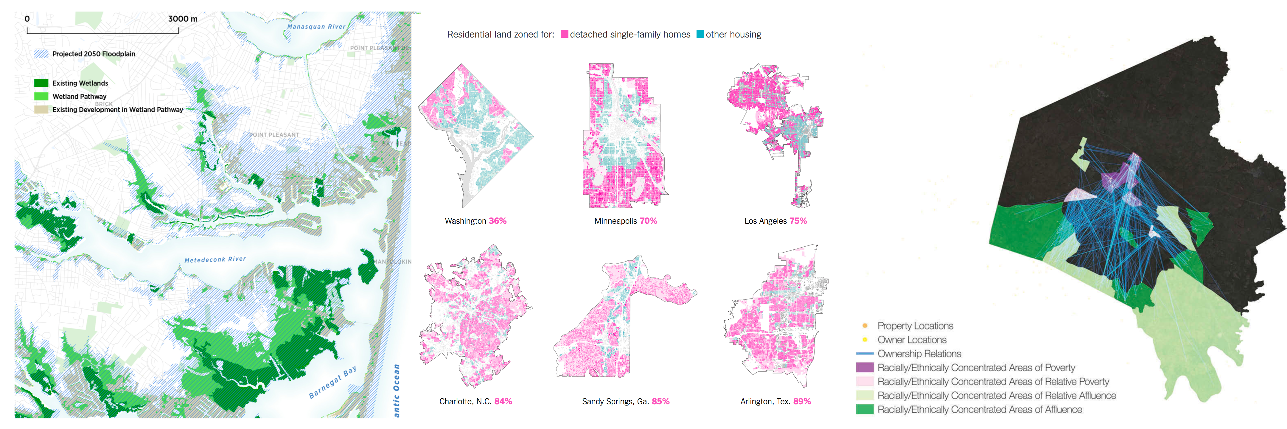
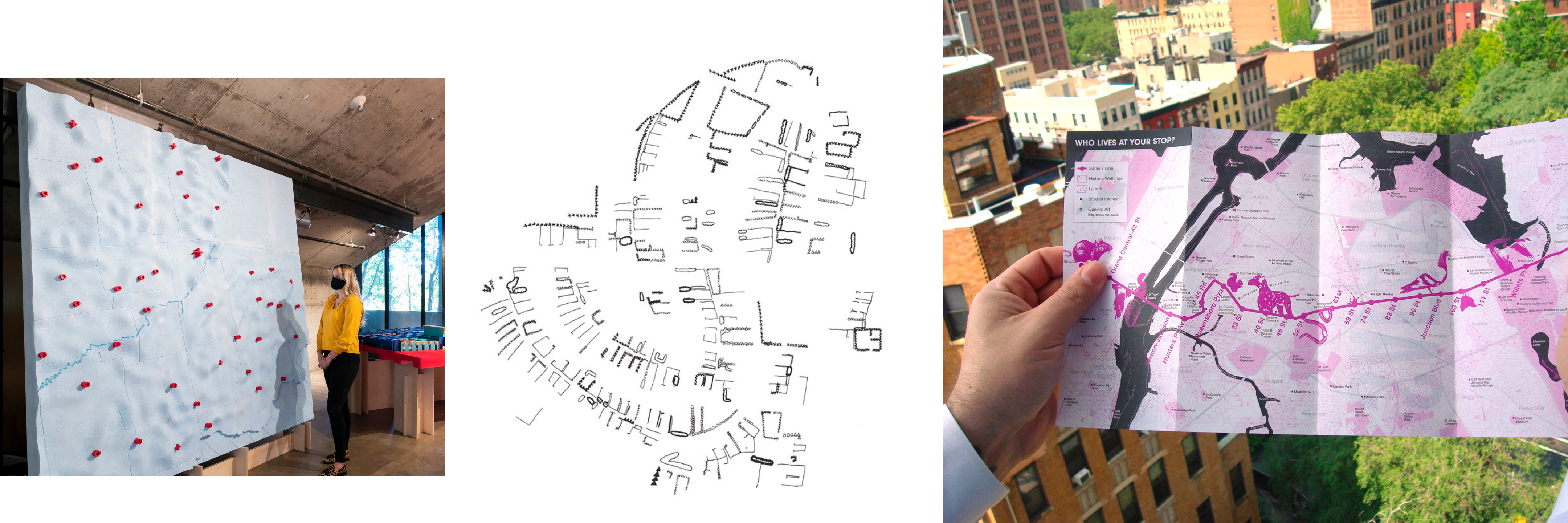
Precedents
As you work to develop your project proposal and project please take a look at a few of these projects chosen as examples for graphic, methodological, and/or narrative approaches.
Weekly Deliverables
This section covers deliverables due each class session and will be updated weekly.
Topic proposal (due 11/4)
Please submit the following on Canvas by 6pm on 11/4
Review the Newark Forward plan and its recommendations. Get familiar with the topics covered and the specific recommendations. Begin to think through: what topics from the plan are most interesting to you? where do topic and/or recommendations overlap with previous projects you’ve done? Either thematically or in terms of the area of Newark that they cover? Do you want to produce a research project or a narrative atlas?
Decide on a preliminary topic and write up a proposal that has the following sections:
- General explanation of research topic (1-2 paragraphs)
- Preliminary spatial research question (more info about this on 10/28)
- Statement about whether you would like the final form of your project to be a research report, or a narrative atlas
- List of datasets that you think you will need to use, identify which ones you already have (with links) and which you might need help to find
- Bibliography with at least three sources aside from the Newark Forward plan relevant to your chosen topic.
Methodology (due 11/11)
The methodology assignment is like a road map for how you will accomplish the remainder of the analytical and cartographic work for your final project. In essence, your methodology is a plan for how you plan to answer your spatial research question. In your methodology you will identify all of the input datasets you need; how you will manipulate them using geoprocessing operations, select by expression operations, table and spatial joins and other methods you have learned this semester; and then what final outputs you will produce. It is also a chance to further refine your question and your topic after searching for datasets and speaking with the instructor and your peers about your topic.
Please submit the following to your final project google drive folder by midnight on Tuesday 11/10
Based on feedback from your classmates and the instructor revise the topic proposal for your project (see instructions for sections to include above). The aim here is to be as clear as possible on what you are investigating (the topic), and what spatial relationships you are seeking to uncover (the spatial aspect of your research question). You must also include an updated list of datasets you will use. Please aim to have located all or nearly all of them, make an appointment during office hours if you are having difficulty here. Save this revised text as a google doc within your final project folder on Google Drive. Use the naming convention 01_topic_revised_last_first
Then based on your spatial question craft a methodology for how you will answer your chosen question. Your methodology should identify:
- Your spatial research question (which clearly states the topic, data used, and spatial relationships to be measured). Please see these slides for examples of spatial research questions from precedent projects.
- Input datasets
- Analytical methods you will use and in what order
- Final outputs
Please provide:
- a narrative methodology, written as clear prose paragraphs outlining the points above. Please upload this to your final project folder as a google doc (named:
02_methods_last_first) - and a methodology diagram (examples of these can been seen in assignment 03 uploaded as a PDF to your final project folder (named:
02_methods_diagram_last_first.pdf) This can be a single page or multiple pages but should be legible and thoughtfully designed.
Methodology Revision & visual precedents (due 11/17 & 11/18)
Building on your work for 11/11 please work on the following
- by midnight on 11/17 please complete a revised version of your narrative methodology & methodology diagram (so that I have a chance to review before class). This should be based on the feedback received on 11/11. By this stage your methodolgy document should clearly articulate:
- your spatial question (and any relevant sub-questions)
- all of the input datasets you will use (include full citation) – & you should have explored each in QGIS to be sure you understand what information they contain and how to use them;
- the steps you will follow to answer your spatial question. Please outline specifically which methods you will use such as which geoprocessing operations, select by expression operations, table and spatial joins and other methods you have learned this semester;
- and then what final outputs you will produce
Upload to your final project folder the narrative methodology as a google doc (named:
03_methods_revised_last_first) and the methodology diagram (named as03_methods_diagram_revised_last_first.pdf) - Before class time on 11/18 please collect design precedents for the look and feel you hope to achieve in the design of your final maps. Please create a google slides presentation containing at least two precedent projects whose aesthetics you would like to draw from in your final maps
- For class on 11/18 also bring with you preliminary work on analysis and output maps showing progress towards the requirements for the final presentation. This will be different for each student and you should have a sense of what you should accomplish here based on our conversation on 11/11.
Project narrative & near-final maps (due 12/2)
Please review the requirements for final formats/outputs listed above.
By 12/2 you should: be finished or nearly finished with your analytical work in GIS; have a clear sense of how you will present your materials on 12/9; have already started to design you final map compositions following from the visual precedents you identified on 11/18.
Please bring to class:
- an outline for your final presentation clearly articulating the content for each of your 10 slides
- completed maps for at least 30% of your presentation slides
This is your last opportunity for feedback prior to the final presentations on 12/9. Please use it wisely!
Image credits (clockwise from top left):
Ellis Calvin, Robert Freudenberg, Sarabrent McCoy. 2019. “The New Shoreline.” Regional Plan Association
Emily Badger, and Quoctrung Bui. 2019. “Cities Start to Question an American Ideal: A House With a Yard on Every Lot (Published 2019).” The New York Times, June 18, 2019, sec. The Upshot.
Taylor Shelton. “Rethinking the RECAP: Mapping the Relational Geographies of Concentrated Poverty and Affluence in Lexington, Kentucky.” 2018.
Galen Pardee. 2020. The Great Lakes. [Exhibition].
Dennis Wood. 2011. “Everything Sings: Maps for a Narrative Atlas”. Places Journal
Scape. 2010. Safari 7.